


Thompson Voting District, Audrain County, Missouri
About
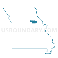
Outline

Summary
| Unique Area Identifier | 607048 |
| Name | Thompson Voting District |
| County | Audrain County |
| State | Missouri |
| Area (square miles) | 93.39 |
| Land Area (square miles) | 92.98 |
| Water Area (square miles) | 0.41 |
| % of Land Area | 99.56 |
| % of Water Area | 0.44 |
| Latitude of the Internal Point | 39.23504260 |
| Longtitude of the Internal Point | -92.03502800 |
Maps


Graphs
Select a template below for downloading or customizing gragh for Thompson Voting District, Audrain County, Missouri


Neighbors
Neighoring Voting District (by Name) Neighboring Voting District on the Map
- Voting District 09, Boone County, MO
- Voting District 12, Boone County, MO
- Voting District 16, Boone County, MO
- Community Voting District, Audrain County, MO
- Friendship Voting District, Audrain County, MO
- Paris Rural 16 Voting District, Monroe County, MO
- Santa Fe 17 Voting District, Monroe County, MO
- Wilson/Salt River Voting District, Audrain County, MO
Top 10 Neighboring County Subdivision (by Population) Neighboring County Subdivision on the Map
- Salt River township, Audrain County, MO (9,497)
- Rocky Fork township, Boone County, MO (8,397)
- Centralia township, Boone County, MO (4,906)
- Jackson township, Monroe County, MO (2,416)
- Wilson township, Audrain County, MO (1,633)
- South Fork township, Monroe County, MO (449)
Top 10 Neighboring Place (by Population) Neighboring Place on the Map
Top 10 Neighboring Unified School District (by Population) Neighboring Unified School District on the Map
- Mexico 59 School District, MO (15,366)
- Centralia R-VI School District, MO (7,249)
- Paris R-II School District, MO (3,081)
Top 10 Neighboring State Legislative District Lower Chamber (by Population) Neighboring State Legislative District Lower Chamber on the Map
Top 10 Neighboring State Legislative District Upper Chamber (by Population) Neighboring State Legislative District Upper Chamber on the Map
Top 10 Neighboring 111th Congressional District (by Population) Neighboring 111th Congressional District on the Map
Top 10 Neighboring Census Tract (by Population) Neighboring Census Tract on the Map
- Census Tract 19.02, Boone County, MO (8,249)
- Census Tract 9502, Audrain County, MO (4,917)
- Census Tract 20, Boone County, MO (4,906)
- Census Tract 9503, Audrain County, MO (3,609)
- Census Tract 9602, Monroe County, MO (2,708)